Snowshoe Hike
- helinjonathan
- May 26
- 5 min read

4-Day Snowshoe Hike at Weidener Hütte
Day 1: Getting to Know Each Other and the Snowshoes
On a Friday in March, we met up with four sporty Dutch women at the parking lot in Innerberg. We did a quick gear check (snowshoes, hiking poles, sunglasses, avalanche transceiver set, etc.) before heading toward the Weidener Hütte. It immediately became clear that this would be a wonderful weekend, as the atmosphere was very relaxed. We started out in our regular hiking boots since there wasn’t much snow yet, the trail wasn’t very steep, and the sun had turned the snow into a nice slushy texture. Once we arrived at the hut — which, by the way, underwent a major renovation in 2008 — we checked in smoothly and prepared our beds.

After that, it was time for another short afternoon tour. Even though the avalanche danger was at level 2, it’s always important to practice these skills — and in this case, teach them to the group. More about why we do this, even though we mainly avoid avalanche-prone terrain, can be found at the end of this blog. So, snowshoes on and off we went! We started by explaining how the avalanche transceiver (beacon) works and what we do afterward with the probe and shovel to dig out a buried person. Then we continued our hike uphill and practiced probing (sticking the probe into the snow to locate a victim). This gave the group a lot of insight into how you can actually feel the difference between hitting a person or an object (like a rock or the ground).
Once we reached a large open area, it was time for the real test: simulating an avalanche with a buried victim. I walked 100 meters farther and buried my backpack with my beacon just out of sight. Then, one by one, they searched for the “victim” using their avalanche transceiver and probe. For many, it was an eye-opener that this does not come naturally, and for experienced people like myself, it’s always excellent training. After all, every second counts in a real emergency. Now we knew we could safely head out over the next few days. Then it was time to descend again and enjoy some well-earned rest and dinner at the hut.
Day 2: Stormy Weather
On day two, the group decided to go for the challenging route: 8 kilometers and nearly 900 meters of elevation gain. The approach followed a wide snowy road that was easy to walk on — and that ideal warm-up turned out to be necessary. As soon as we left the road, the climb became quite steep.
Although the clouds looked stormy, it was still very pleasant to be out hiking. The sun occasionally peeked through and the views were breathtaking. Of course, we regularly stopped for a snack, something to drink, and a chance to catch our breath. We had planned our picnic at the summit so we could enjoy views across all the surrounding peaks.
But just before reaching the summit, we were surprised by extremely strong gusts of wind. The wind had been hiding behind the mountain. Suddenly, everyone understood what the “wind chill” effect really means. The stronger the wind, the faster the warm air around your body gets blown away, making it feel much colder.
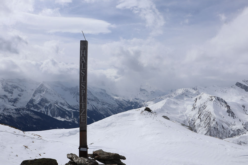
We decided to leave the Halslspitze (2574 m) behind quickly and have lunch once we found a more sheltered spot away from the strong wind. Gradually it became warmer again as we descended lower into the valley. Did you know that the average temperature in the mountains drops by 0.7°C for every 100 meters you climb? After lunch we continued hiking, and after another short steep section we safely arrived back at the hut. While enjoying delicious hot chocolate and a three-course meal, we reflected on the beautiful adventure we had experienced that day.
Day 3: (Un)Expected Avalanche Danger
During breakfast, I could tell the group was starting to feel a bit tired, but their motivation was still very high. So we decided to stay a little closer to the hut and slightly lower than the previous day, while still doing a ridge hike with three summits.
We started on steep and fairly difficult terrain. The clouds hung low that day, making it challenging at times to find the correct and safe route. Because of the strong winds the previous day, a lot of snow had drifted. In some places this created deeper loose snow, while in others there was more compact, older snow. Although loose snow is much more pleasant for snowshoeing, it can also be dangerous. During those days, avalanche danger was level 2 above the tree line — where we were usually hiking.
Then, a few hundred meters below the summit, I heard sounds coming from beneath the snow. It’s a sort of muffled “whoomph” noise that starts beneath your feet and travels through the snowpack. This means there is a weak layer in the snow that is collapsing.
Normally, during snowshoe hikes, we always stay away from avalanche-prone zones and therefore avoid slopes steeper than 30°. But to be extra safe, we moved slightly more onto a small ridge where I could occasionally see the ground beneath us. That meant there was very little snow under our feet, making it much safer.
From that point on, we became even more cautious, kept at least 10 meters distance between each other, and I kept the topographic map on my phone close at hand. This allowed me to choose the safest route with greater precision. Just before the summit there was a difficult passage: on both the left and right were narrow sections (less than 10 meters wide) that exceeded 30° in steepness. We passed right in between them.

While standing on top of Nafingköpfl (2454 m), Aya — who had joined us as a photographer — came up to me and told me what she had just seen happen: an avalanche that we had remotely triggered. In the photo, you can clearly see that an avalanche had occurred to our right. It was a small avalanche, but because the slope became steeper farther away from us, it spread quite wide.
There was never any danger to us because we had chosen the correct route. But it shows that even with a relatively low avalanche warning level and little fresh snow, the danger is never completely gone. As mountain hiking guides, we are trained to recognize these hazards. That’s why we accounted for them and consistently stayed away from steep terrain (>30°).
Since no one in the group had actually seen the avalanche happen, we discussed it on the way back. After lunch, we descended and, once we were farther away, I showed the group exactly what had happened. After answering all their questions, everyone felt ready to continue.
Because of limited time and enough excitement for one day, we decided after the second summit, Hoher Kopf (2375 m), to descend back toward the Weidener Hütte. After about a kilometer, we followed the same route we had used on Friday. Back at the hut, we talked more about how avalanches form, what you must do to avoid them, and concluded that we had made the right decisions. Olaf, a very friendly hiking guide from Germany, joined the conversation, which was also very interesting for us.
Day 4: A Sunny Ending
After a good night’s sleep, we packed our backpacks one last time for a final outing. We could leave the items we didn’t need in the boot room and pick them up later. It would be a short hike of only two kilometers to Hubertusspitze (2205 m), a small point on the flank of the Hobarjoch.
Up there, it was wonderful to relax in the sunshine. Then it was time for the final descent. We enjoyed one last delicious lunch at the hut before heading back to the cars. With every step downward, the air became warmer and it truly started to feel like spring again. I couldn’t have imagined a more beautiful ending to this fantastic four-day adventure.

Comments